
Although the Granite Wash is now known as an unconventional gas and oil play in the Anadarko Basin, it was not always unconventional. Many Granite Wash reservoirs have produced since the 1950s and 1960s. The advent of horizontal drilling and multistage hydraulic fracs in recent times has turned marginal and non-economic formations into attractive horizontal development targets.
Throughout the Pennsylvanian Period a large mass of conglomeratic “Granite Wash” material was dumped into the Anadarko Basin. The Granite Wash material created a unique facies within the normal Pennsylvanian depositional environment. The large stack of Pennsylvanian Granite Wash formations provides many targets for horizontal drilling, but with 10,000 to 15,000 ft of Granite Wash sediment and 90,000 existing vertical well penetrations in the “play” area, this represents a logistical exploitation problem for many prospective drillers.
When describing a complex system such as the Granite Wash, commonly we refer to the old-timers' descriptions of the basin and depositional processes. The early pioneers looked at a basin as a whole entity because they had only limited data such as cuttings, cores, and early well logs spread across the basin.
In contrast, this article is based on a study of 35,000 digital well logs pulled from the 90,000 existing vertical wells within the Granite Wash play area. By manipulating this information, we can now create basin-wide cross sections and maps that give us an earthworm’s view of the Granite Wash. Using the latest technology, we now have the luxury of seeing hundreds of digital well logs simultaneously that not only give us a broader understanding of basin-wide depositional features, but also the ability to take an up-close view of the depositional facies.
This article will attempt to illustrate the multiple horizontal Granite Wash targets currently being exploited by various operators. The maps and cross sections in this article are a product of a 35,000 digital well log database. Using the database, a digital stratigraphic framework with basin-wide correlations has been created to subdivide the complete Pennsylvanian Granite Wash section into 60 time slices.
Basin-Wide Context
Although Granite Wash beds are spread among the Anadarko, Dalhart, and Palo Duro basins, the traditional Granite Wash play is found in the Anadarko Basin.
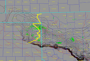
Figure 1. Isopach: Cleveland to Oswego (Images courtesy of Reservoir Visualization). Note: Green Wells: Horizontal Wells Drilled in 2008 and 2009 (Source: IHS)
“Formation of the Anadarko Basin began during the collision of Gondwana, with a southern continental margin of Paleozoic North America. Structural inversion of the core of the southern Oklahoma aulacogen into the Wichita thrust belt caused thrust loading of the region to the north, which subsided and became the Anadarko Basin. Late Pennsylvanian transpression formed numerous thrust-cored, en-echelon anticlines within the southeastern part of the basin that were later eroded and overlain unconformably by Permian carbonates. Subsidence of the basin continued into middle Permian time. The basin has remained quiescent since later Permian time.” (Perry 1989)
One of the deepest basins in the US, the Anadarko Basin, contains over 40,000 ft of Paleozoic sediments. The basin is asymmetric with its deepest part near the southern border of the Wichita-Amarillo Complex. It is bordered on the east by the Nemaha Granite Ridge, on the south by the Wichita Uplift and on the west by the Cimarron Arch. Figure 1 is an isopach map of the Anadarko Basin’s shape during the middle of the Granite Wash era from the Cleveland (early Missourian series) to the Oswego (Desmoinesian series).
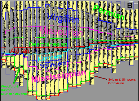
Figure 2a: Type Section of Granite Wash
Many of us can recall with familiarity the intense drilling activity in the Anadarko Basin not very long ago. Wells were drilled to the Hunton – with Hunton, Morrow and Springer targets as deep as 25,000 ft. Some of the exploration targets were dry wells, but there were always the behind-pipe targets uphole in the Pennsylvanian formations. Most commonly these were Granite Wash targets and today more than 4,200 wells have been completed in the various Granite Wash reservoirs. Figures 2a and 2b is a generalized stratigraphic section of the Anadarko Basin and represents the A-B Cross Section cutting through Figure 1.
The Granite Wash
The term “Granite Wash” refers to “sediments that were derived principally from the weathering of granitic rocks, and that generally bear a strong resemblance to the original material…(it is) composed mainly of sediments derived from the uplifted Wichita Mountains” (Gelphman 1960). The conglomerates and arkoses, generally referred to as Granite Wash,

Figure 2b. Geologic column of the Granite Wash.
may, in a few miles, grade laterally into shales, which indicates that basin sedimentation was progressing without interruption, while local pulses were occurring nearby. “During Pennsylvanian and early Permian time the pulsations and local uplifts of the Wichita orogeny are reflected by the repetition of coarse conglomerates or arkoses and shale beds” (Gelphman 1960).
“Fault displacement along many of these uplifts was predominantly vertical, the Amarillo uplift is apparently bounded by a high-angle reverse fault zone” (Goldstein 1981). The basin must have been subsiding rather rapidly to absorb all of the eroded sediments. The sediments carried down from the uplifted mountains must have been deposited below wave base or subject to a turbulent environment for an extremely short time as the dumped-in appearance suggests.
Likewise, evidence of some transportation is shown by the slight rounding of pebbles and their heterogeneous composition. Most Granite Wash pebbles are composed of granitic rocks, limestones, dolomites, and some chert and are well rounded to subrounded and range from 4 mm to 31.7 mm. Matrices of different beds contain both light and dark shales and may indicate periods of reducing conditions and periods of oxidizing conditions. The immaturity of the sediments is reflected by fresh-appearing granite rocks, extremely poor sorting, high feldspar/quartz ratio and angularity of particles.
In order to allow a meaningful production history review and facies analysis, the 10,000 to 15,000 ft of Granite Wash must be subdivided into time slices of 50 to 200 ft. Each time-slice has a Granite Wash facies that extends into the basin relative to Granite Wash sediment supply and source direction. Granite Wash sediment, however, does not guarantee porosity. Therefore, an analysis of porous facies versus non-porous Granite Wash facies is still required.
The Granite Wash Challenge
“Correlation problems have long existed between the Pennsylvanian marine clastics of the northeastern half of the Anadarko Basin and Shelf and the Pennsylvanian terrigenous washes of the extreme southwestern portion of the
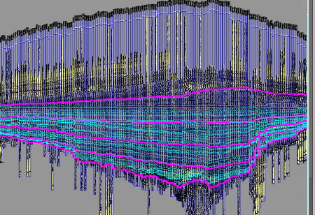
Figure 3. Pennsylvanian Series and Internal Time Markers
Anadarko Basin. These correlation problems have created nomenclature problems resulting in thousands of feet of washes often referred to on completion and production records as Granite Wash or Atoka Wash and many other names with no Granite Wash reference, when much greater accuracy and specificity is both needed and possible” (Hendrickson, et al, 1996).
“Certain markers proved to be regionally persistent from the marine clastics into the terrigenous washes making the subdivision of thousands of feet of washes possible. Those of greatest importance were the top of the Marmaton, the Cherokee Marker, the Pink "Limestone" interval, and top of the Atoka and top of the Morrow” (Hendrickson, et al, 1996). The digital advantage capitalizes on these markers, which are correlated in thousands of wells.
The time markers available in the Anadarko Basin are sometimes pairs of thin high gamma ray markers that are laterally persistent throughout the basin, but the problem is that these markers are lost when facies changes occur. Digital visualization with greater visual breadth of the geologic section solves this problem by seeing other markers continue when one is lost in a facies change while others continue. Figure 3 is a detailed Granite Wash stratigraphic framework with all time markers visible.
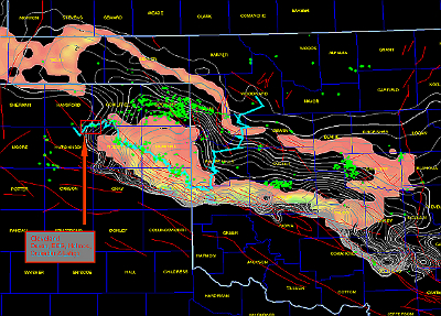
Figure 4. Map of a one-time slice (early Oswego) of Anadarko Basin reveals where dolomized shelf carbonates and Pennsylvanian Granite Wash sediments were deposited simultaneously.
Figure 4 is a map of one time slice (early Oswego) of the Anadarko Basin where dolomitized shelf carbonates and Pennsylvanian Granite Wash sediments were being deposited simultaneously. Of note in the map are: (a) the gross isopach of the Cleveland and Oswego formations designated with grey contour lines; (b) the net clean Gamma Ray isopach of an early Oswego time slice shown with color-filled contours; (c) the location of horizontal wells drilled in the past two years (per IHS); and (d) the location of cross section C to D that intersects several of the areas with horizontal drilling activity.
The color-filled contours (net clean gamma ray) illustrate clearly that low API Granite Wash sediments are collecting in the basin’s depocenter north of the Wichita Uplift where accommodation space is available. The other trend of low API carbonate material exists along the basin margin to the northeast, north, and southeast, which is one early piece of the Oswego reef. Note that the position of the reef closely follows the shelf break.
Horizontal drilling requires a small, focused target or layer to be effective. Because the Granite Wash facies exists in most layers, each layer of the Pennsylvanian Granite Wash section must be prospected independently. The record of completions and attempts in well records and production reports contains a wealth of information from which a horizontal Granite Wash prospect could develop. The stratigraphic framework plays a role for required horizontal prospecting, possibly more important than mapping depositional systems. The stratigraphic framework subdivides all completion attempts along with shows into zones less than 100 ft, which. The challenge, then, is to compress the time required to prospect 100 layers.
Current Horizontal Drilling Activity
If you follow the cross section beginning in the west, in Hutchinson County, Texas, you will see that the first area of horizontal activity (Hutchinson/Hansford Counties) is mainly Cleveland (late Missourian). The source of the Granite Wash sediments for the Cleveland (late Missourian)and the Virgilian above appear to be from the west. Operators active in this play include Devon, EOG, Holmes, Crusader, and Latigo.
In Ochiltree and Roberts counties, horizontal activity is mainly in the Atokan with laterals drilled in both the Atoka A and Atoka B. This activity appears to be on the western flank of the Atokan Granite Wash facies. Operators active in this area include Forest, Cordillera, Range, EOG, and Chesapeake. Also in Roberts County, EOG and Chesapeake have made several horizontal attempts in the Desmoinesian.
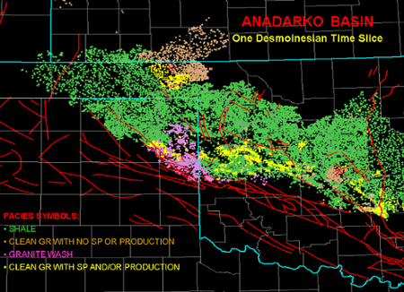
Figure 5. Anadarko Basin: One Desdemonian Time Slice
Figure 5 is a prototype facies map from a Desmoinesian time slice that shows similar development of productive facies to the west.
The next significant area of horizontal activity is in eastern Roberts County where Sampson and Mewbourne are drilling laterals into the Red Fork (early Desmoinesian). The massive amount of Granite Wash sediments are clearly to the east in the cross-section view.
The Atokan is again being developed by Cimarex, Jones, and Sampson in southeast Roberts and Hemphill counties. This Atoka A productive facies is also on the western flank of the Granite Wash facies.
Hemphill County also has significant horizontal activity in the Upper Red Fork (late Desmoinesian). Figure 4 displays many vertical Red Fork completions in the productive Granite Wash facies. The cross section is passing through a massive amount of Granite Wash material in Hemphill County making any observations difficult. Operators in this Granite Wash play include Devon, Cimarex, Forest, Noble, and Sampson. A lower Atokan horizontal attempt by Devon in the Atoka B is also noted in Hemphill County.
Extensive horizontal development is being conducted in the Oswego (late Desmoinesian) in Wheeler County by Devon, Chesapeake, Sampson, and Newfield. This productive Granite Wash facies is clearly in the Granite Wash facies depocenter depicted in Figure 4, which is from an Oswego time slice.
According to Peggy Williams, senior editor of Oil and Gas Investor, “Given the tremendously thick section of the stacked intervals that occurs in the Granite Wash at Stiles Ranch, selecting a horizontal target is not simple.”
“The difficult part is to bore in on how productive each zone is,” said Newfield President George Dunn. “We use vertical production data, production logs, and petrophysical analysis to determine the zones with the highest productivity. We're targeting intervals that can deliver high production rates."
Wheeler County also contains a Lower Cleveland horizontal play being conducted by Newfield and Chesapeake. The location of the main Granite Wash facies cannot be determined by this cross-section traverse.
Crossing into Oklahoma, this traverse is intersecting mainly marine clastics. Several horizontal tests have been conducted in the Lower Red Fork (Desmoinesian) by Newfield. Other horizontal tests in central/north Roger Mills County have been attempted by Burlington and Chesapeake in the Desmoinesian Upper Red Fork.
Summary
The Anadarko Basin represents approximately one fifth of the onshore wells in the US. The 40,000 ft of prospective section represents an extremely large challenge to the Basin’s many operators. With this challenge comes the enjoyment of visualizing and mapping the diverse set of depositional environments. Digital databases and modern software are allowing us to analyze this extremely large basin from shore to shore. All 360 degrees of the basin’s margin are preserved in the column; therefore, any depositional feature active in each geologic moment of time can be analyzed as a complete system.
The Pennsylvanian Granite Wash portion of the Anadarko section is showing much promise as a horizontal exploitation target. It is encouraging to see that recent horizontal completions are being carried out through many different formations or time slices; therefore, optimism exists to see exploitation potential in most of the basin’s formations.
The challenge is to move ahead of the drill bit to map each Pennsylvanian time slice and create new horizontal prospects. While mapping these time slices we will be viewing spectacular reefs, deltas, offshore bars, and the Anadarko Granite Wash features. Each piece of digital data or digital interpretation saved at any level of the geologic column will expedite the creation of future prospects.
Recommended Reading

Classic Rock, New Wells: Permian Conventional Zones Gain Momentum
2024-12-02 - Spurned or simply ignored by the big publics, the Permian Basin’s conventional zones—the Central Basin Platform, Northwest Shelf and Eastern Shelf—remain playgrounds for independent producers.

First Helium Plans Drilling of Two Oil Targets in Alberta
2024-11-29 - First Helium Inc. has identified 10 other sites in the Leduc formation.

DNO Discovers Oil in New Play Offshore Norway
2024-12-02 - DNO ASA estimated gross recoverable resources in the range of 27 MMboe to 57 MMboe.

Freshly Public New Era Touts Net-Zero NatGas Permian Data Centers
2024-12-11 - New Era Helium and Sharon AI have signed a letter of intent for a joint venture to develop and operate a 250-megawatt data center in the Permian Basin.

DNO Makes Another Norwegian North Sea Discovery
2024-12-17 - DNO ASA estimated gross recoverable resources in the range of 2 million to 13 million barrels of oil equivalent at its discovery on the Ringand prospect in the North Sea.
Comments
Add new comment
This conversation is moderated according to Hart Energy community rules. Please read the rules before joining the discussion. If you’re experiencing any technical problems, please contact our customer care team.