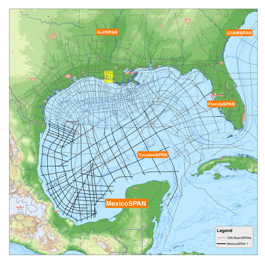
To help E&P companies identify new exploration opportunities in the deepwater Gulf of Mexico (GoM), ION is providing a deep-imaged regional set of 23,000 km (14,292 miles) of 2-D seismic data in Mexican federal waters. This new acquisition program, MéxicoSPAN, along with ION’s existing YucatánSPAN, GulfSPAN and FloridaSPAN programs, is designed to allow explorationists to fully integrate seismic, well and outcrop information onshore East Texas, Louisiana or Florida, in the ultradeep waters of the central GoM and in the proven and potential hydrocarbon provinces offshore Mexico.
Until earlier this year, ION had the energy industry’s only regional 2-D seismic data throughout the southern GoM—YucatánSPAN. With this new acquisition, explorationists can improve their understanding of the basin architecture and evolution as well as high-grade areas for hydrocarbon prospectivity, which might result in the identification of additional leads or prospects while reducing overall exploration risk.
The regional extent of the program is designed to provide full, seamless coverage of the prolific E&P areas of the western GoM as well as the exploration frontier areas within the ultradeep waters between Florida and the Yucatan peninsula. These data can be used to correlate well information from the data-rich areas offshore the U.S. into frontier exploration areas offshore Mexico. They also can be used to help correlate zones of production in carbonate plays in the southern GoM into frontier areas of the U.S. such as offshore Florida.
The new data were processed using ION’s processing technologies and leveraging experience in seismic processing, depth imaging and acquisition in Mexican and U.S. waters. These data could provide the basis for this license round as well as future rounds. Underwriters of the program already have received fast-track migrated products to assist in their evaluation of the
open acreage in the Perdido Fold Belt and the southern Bay of Campeche salt basin as well as lines connecting the northern and southern ends of the GoM for a basinwide understanding. The final processed data will be completed in early 2016 along with interpretation products such as regional horizon surfaces (time and depth) and gravity modeling.
With Phase I complete and 3-D data soon becoming available from Mexico’s Comisión Nacional de Hidrocarburos and wide-azimuth seismic contractors, additional acquisition phases can enhance the program with the precise amount of 2-D data necessary to better identify the size and location of major prospective structures. This combination of regional 2-D and local 3-D data can enable geoscientists to more efficiently evaluate risk through a broader understanding of the basin’s evolution, architecture and hydrocarbon potential.
Recommended Reading

Crescent Energy Closes $905MM Acquisition in Central Eagle Ford
2025-01-31 - Crescent Energy’s cash-and-stock acquisition of Carnelian Energy Capital Management-backed Ridgemar Energy includes potential contingency payments of up to $170 million through 2027.

Petro-Victory Buys Oil Fields in Brazil’s Potiguar Basin
2025-02-10 - Petro-Victory Energy is growing its footprint in Brazil’s onshore Potiguar Basin with 13 new blocks, the company said Feb. 10.

Apollo Funds Acquires NatGas Treatment Provider Bold Production Services
2025-02-12 - Funds managed by Apollo Global Management Inc. have acquired a majority interest in Bold Production Services LLC, a provider of natural gas treatment solutions.

VAALCO Acquires 70% Interest in Offshore Côte D’Ivoire Block
2025-03-03 - Vaalco Energy announced a farm-in of CI-705 Block offshore West Africa, which it will operate under the terms of an acquisition agreement.

ENGIE Adds 900 MW Solar, Storage to Portfolio from Ares Management
2025-03-25 - The addition brings ENGIE North America and Ares Management’s partnership to 3.7 gigawatts of investment in U.S. generation.
Comments
Add new comment
This conversation is moderated according to Hart Energy community rules. Please read the rules before joining the discussion. If you’re experiencing any technical problems, please contact our customer care team.