
TGS stated that the FWI enhances the structural image of the Wolfcamp and Bone Spring intervals main reservoir zones. (Source: Shutterstock)
TGS has released volume data, collected from its Dynamic Matching FWI (full-waveform inversion), from the West Kermit 3D seismic survey in the Delaware Basin, TGS announced June 17.
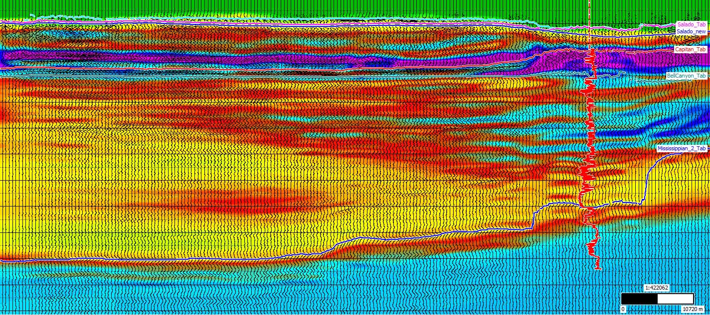
With the goal of enhancing its subsurface insights, the final new data volumes include time reprocessing and a fully integrated depth model for diving wave and reflection Dynamic Matching FWI.
West Kermit spans 1,054 sq km across Loving and Winkler counties, Texas and aids in evaluating and developing multi-targeted Delaware Basin acreage.
TGS stated that the FWI enhances the structural image of the Wolfcamp and Bone Spring intervals main reservoir zones.
“These new volumes from our onshore processing team’s efforts on West Kermit 3D mark an important milestone in TGS' onshore strategy and provides a platform for future growth in this prolific area,” said David Hajovsky, executive vice president of Multiclient at TGS.
The enhanced image now shows visible depositional transitions from the Capitan Reef—found in western Texas and southeastern New Mexico—to the basin clastic deposits of the Delaware Mountain Group.
“When combined with our geological database and interpretive products, we are well positioned to enhance subsurface insight and decision-making for exploration and development efforts in the Permian Basin,” Hajovsky said.
RELATED
TGS, PetroAI to Develop Earth AI Models for Well Performance, Design
Recommended Reading

E&P Highlights: Feb. 24, 2025
2025-02-24 - Here’s a roundup of the latest E&P headlines, from a sale of assets in the Gulf of Mexico to new production in the Bohai Sea.

ADNOC Contracts Flowserve to Supply Tech for CCS, EOR Project
2025-01-14 - Abu Dhabi National Oil Co. has contracted Flowserve Corp. for the supply of dry gas seal systems for EOR and a carbon capture project at its Habshan facility in the Middle East.

Partnership to Deploy Clean Frac Fleets Across Permian Basin
2024-12-13 - Diamondback Energy, Halliburton Energy Services and VoltaGrid are working together to deploy four advanced electric simul-frac fleets across the Permian in an effort to enhance clean and efficient energy solutions in the region.

Tracking Frac Equipment Conditions to Prevent Failures
2024-12-23 - A novel direct drive system and remote pump monitoring capability boosts efficiencies from inside and out.

ProPetro Agrees to Provide Electric Fracking Services to Permian Operator
2024-12-19 - ProPetro Holding Corp. now has four electric fleets on contract.
Comments
Add new comment
This conversation is moderated according to Hart Energy community rules. Please read the rules before joining the discussion. If you’re experiencing any technical problems, please contact our customer care team.